


1800-1869
This Timeline is an ongoing project to chronicle the History of the Ballachulish area. If you notice any errors or omissions, please contact Rob Malpas at rileyrob@btinternet.com. Thank You. Photos on this page are copyright Rob Malpas unless otherwise stated.
1800
Ferry House Inn – 25th July 1880
Dr Thomas Garnett undertook a tour of the Highlands in 1800, and wrote an ‘Observation’ or diary of his journey. He had the following to say of his stay at the Ballachulish Ferry House:
“We found the accommodation both for ourselves and our horse at the ferry-house of Ballichellish very uncomfortable, but being fatigued by the labour and heat of the preceding day, we slept tolerably, and early the next morning set off for Glencoe.”
Read More: Thomas Garnett on Wikipedia
1801
John Stoddart visits Ballachulish
After over a Decade at Christ Church College in Oxford, Stoddart undertook a tour of Scotland in 1801. He was later to be editor of The Times, but his main career was as a lawyer and later Judge. He wrote about his tour of Scotland in ‘Remarks on the Local Scenery and Manners of Scotland’ and has this to say about his stay in Ballachulish:
“A mile or two more brought us to Ballachulish, where we experienced the warmest welcome from Captain and Mrs Stewart… The landscape is continually varied, by cottages, by the great slate-work of Ballachulish, by a lime-kiln, and various other objects on the wayside; by the islands in the lake; and by the woods and residences at the base of the mountains.”
Read More: John Stoddart on Wikipedia
Ballachulish Ferry Inn
The same year, Mrs Mary Aust wrote a ‘Companion and Useful Guide to Beauties of Scotland’ in which she says that “The Inn at Bailechoalish is small, but it was neatly kept by a new landlady. In general it is ill kept.” This seems to support Garnett’s opinion of the previous year, but suggests that the new landlady may be trying to improve matters. There are further words of warning, however, as she also claims that it once took 11 hours to do the ‘about 26 miles’ from Oban to Ballachulish, thanks to the lack of people available to help load her carriage at Connel and Shian ferries. Sadly there is no mention of her experience with the Ballachulish Ferry.
1817-21
Thomas Telford
The Commission for Highland Roads and Bridges, under the supervision of Thomas Telford takes over responsibility for the Military Roads and also the Glencoe Drove Road. Subsequent to this, improvements are carried out on the route along Loch Leven and over the Ballachulish Ferry.
In 1819, on their tour of Telford’s Works, Thomas Telford, his colleagues Joseph Mitchell and John Rickman and their friend the poet Robert Southey stayed at Ballachulish Ferry for the night. Because neither Inn had enough room for all of their party, they split into two groups, half staying on each side of the ferry.
Telford was later responsible for the commission which saw Churches and Manses built at Creag Mhor, North Ballachulish (now demolished), Duror and Ardgour.
Read More: This is a full online copy of Robert Southey’s and therefore a large pdf file – Journal of a tour to Scotland, 1819
1819
First Steamer on Loch Linnhe
The Clyde based Steamer Comet first sailed from Glasgow around Kintyre and on to Oban and Fort William in the summer of 1819. Whilst Ballachulish is not mentioned on the official timetables, documentary evidence shows that a number of often un-named request stops were made wherever there was a suitable pier, so it is possible that Comet stopped in the Ballachulish area that first year.
Read More: PS Comet on Wikipedia
1822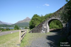

Slate Arch built
The recorded date of construction for one of the Slate Arches is 1822. At various times, however, there appear to have been arches in at least three different places, and it is unclear which arch this date refers to, nor whether it was the initial construction or a reconstruction. One reference suggests it was the ‘Big Arch’ which stood between the surviving arch and the quarry entrance that was built in 1822. The arches were built to carry inclined tramways which lowered wagon loads of Slate from the upper levels of the quarry down to the shore for working and loading onto the waiting boats.
Read More: Ballachulish Slate Arch
1829
North Ballachulish Manse and Church
The former Manse for the Church of Scotland in North Ballachulish was built to the commissioners design in 1829. The commission was under the supervision of Thomas Telford, who had already built a number of roads in the area, and almost certainly overseen some work on the road past the manse itself! This Manse related to the former parliamentary church at Creag Mhor, which was built at the same time and demolished in 1900, of which only the graveyard remains.
Read More: Parliamentary Kirks on Geograph
1831
Visit by William Turner
The renowned artist William Turner visits the West Highlands by steamer and alights at North Ballachulish Pier. His notebook includes a couple of sketches of ‘Bala’, including one showing an arched bridge and house in the foreground with a landscape of the Pap of Coe, roughly as seen from St John’s Church. This suggests that the river there was previously spanned by a hump-backed arch bridge similar to the Brig O’Laroch, and probably dating back to the Drove Road as built in 1785/6.
Read More: Turners Sketchbook at Tate Gallery
Croft Road Cairn
The Cairn which once stood between Leven Terrace and Croft Road was opened and removed in 1831. A slate marker now stands to mark the spot, with the following inscription:
In April 1831 a cairn which stood on this spot was removed. The stone coffins within the enclosure were found underneath and had been left undisturbed. Neither bones, ashes nor any remains of antiquity were discovered. To preserve the sanctuary of the place, the surorunding wall was erected by Charles Stuart Esq of Ballachelish.
The Slate is known locally as the Witches Grave, although the origin of this name is unclear. Other cairns in The Croft were cleared in the 1940s, with Croft Road believed to have been built on their site.
1834
Road Improvements
James Johnson records that in autumn 1834 the road to Ballachulish is undergoing work with the Highland men working on it referred to as ‘Macadamisers’ referring to the process of road building invented by MacAdam which led to modern Tarmac. It appears that the work was on Rannoch Moor at the time, but implies that the whole road was being improved. Work was apparently progressing at the rate of a mile a month.
1836-45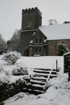
Ballachulish Churches
It is perhaps quite remarkable that all three of the surviving churches in Ballachulish date from such a short timeframe of less than a decade:
St Mun’s Catholic Church was built in 1836, and is apparently unchanged today, apart from the addition of the later Priests House to the side, which is still not shown on the 1898 map. The original priests house is the rear part of the main church building.
St John’s Episcopal Church on the shore of Loch Leven followed in 1842, and was later extended in 1888. The rectory is from the 1860s, although to the rear is part of an older house dating from 1838. Of all of the churches, it seems that St John’s is the only one to stand on an older site, with records taking the site back to 1770 when what is now (and perhaps was then) the hearse house was used by the Bishop as a chapel, and was indeed later consecrated as such.
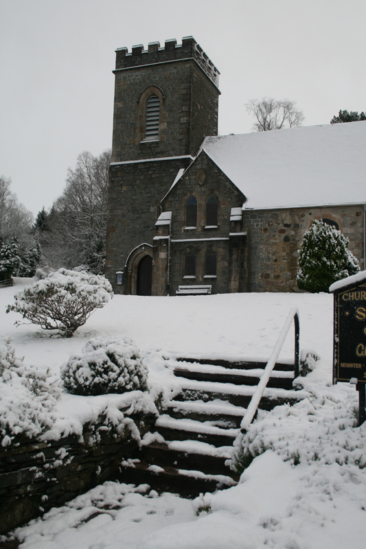
St Munda’s Church of Scotland is the newest of the three which opened in 1845 and was extended in 1881, when the tower was built. The Manse was built up the hill after the 1872 OS map.
Other churches were the Free Church of 1874 which formerly stood opposite the School in School Brae and the Episcopalian chapel, known as the Banks Church which stood amongst the quarriers cottages in the vicinity of where the Village Hall now stands, and included a schoolroom. The original Free Church Manse is now Glen Morvern House at the end of Argyll Cottages.
1841
New Statistical account
Mountains – “Next to these [Glencoe] in importance, and certainly not second to them in beauty, are the hills of Bailechelish, rising in beautiful pyramidal form immediately behind the residence of Charles Stewart Esq. Of Bailechelish. These hills, the highest of which may be about 2000 feet above the level of the sea, are covered almost to the top with the richest verdure, and ornamented with a few venerable trees scattered here and there over the surface the representatives of the ancient Caledonian forest, which terminated on the west at this point. The highest of the Bailechelish hills is called Beinn-bheithir, i.e. the mountain of the thunderbolt, perhaps from the singed red appearance of its two pointed pinnacles. For two thirds of its height, it is covered with fine and luxurious pasture, but its top id perfectly barren, composed of a mixture of Granite and Whinstone and covered with white moss, a fit habitation for the ptarmigan and mountain hare.”
Meteorology – “The following is a summary of a journal of the weather kept at Bailechelish, in Appin, indicating the temperature of the atmosphere, as ascertained daily, monthly and annually during the years 1837, 1838 …”
| 1837 | 1838 | |||||||||||||
| Thermometer | Fair | Rain | Thermometer | Fair | Rain | |||||||||
| AM | Noon | PM | All Day | * | All Day | * | AM | Noon | PM | All Day | * | All Day | * | |
| Jan | 38 | 40 | 38 | 13 | 17 | – | 1 | 32 | 36 | 39 | 19 | 10 | 2 | – |
| Feb | 36 | 39 | 36 | 9 | 4 | 3 | 12 | 29 | 35 | 31 | 25 | 3 | – | – |
| Mar | 32 | 42 | 35 | 10 | 7 | – | 4 | 37 | 43 | 39 | 11 | 13 | 3 | 4 |
| Apr | 35 | 47 | 40 | 16 | 14 | – | – | 40 | 47 | 41 | 14 | 11 | 3 | 2 |
| May | 46 | 53 | 49 | 19 | 11 | – | 1 | 46 | 56 | 48 | 22 | 7 | – | 2 |
| Jun | 54 | 63 | 56 | 19 | 11 | – | – | 54 | 62 | 55 | 7 | 17 | 1 | 5 |
| Jul | 58 | 66 | 59 | 13 | 17 | – | 1 | 56 | 63 | 56 | 8 | 16 | 2 | 5 |
| Aug | 58 | 63 | 57 | 18 | 8 | 1 | 4 | 58 | 61 | 58 | 7 | 12 | 2 | 10 |
| Sep | 50 | 58 | 53 | 17 | 10 | – | 3 | 49 | 57 | 50 | 11 | 10 | 2 | 7 |
| Oct | 48 | 53 | 49 | 4 | 12 | 1 | 14 | 43 | 50 | 53 | 9 | 13 | 2 | 7 |
| Nov | 40 | 43 | 40 | 9 | 9 | – | 12 | 38 | 42 | 39 | 11 | 17 | – | 2 |
| Dec | 44 | 46 | 44 | 12 | 13 | 2 | 4 | 41 | 44 | 41 | 7 | 17 | 1 | 6 |
Antiquities – “There are several of these tumuli [Cairns] on the property of Mr Stuart of Bailechelish, who a few years ago began to remove one of them with a view to clear the field in which it stood, of what he believed to be merely a heap of stones, but, as the workmen proceeded, they found in the centre of the tumulus a rude stone coffin containing nothing within it, and instead of removing the whole, as first intended, Mr Stuart, with proper feeling, ordered the sacred relic to be left undisturbed; built a wall round the place, planted some trees within the enclosure and reared a stone pillar on which is engraved the time when, and the circumstances under which, they were found.”
Quarries and Mines – “There is at the foot of Glencoe, on the farm of Laroch, the property of Charles Stuart Esq. Of Bailechelish, a slate quarry, which has for many years been extensively wrought and from which large quantities of the best slates are yearly manufactured. … The harbour which is safe and commodious, is formed by the banks of rubbish projecting into the sea on each side, which completely shelter it from all winds. There is an extensive wharf for shipping… The whole number of persons employed in the works is about 800 of all ages…”
Housing – “Upwards of three-fourths of the men employed in the quarries have their houses on the Bailechelish Estate, and the houses are built with stone and lime and slated. The accommodation in each is three apartments, all plastered, with chimnies and grates in the principal one and an open garret above. To most of them a cow-house is attached, as almost every man with a family has a cow, which is pastured on the adjoining hill, and also a piece of ground which produces annually from two to two and a half tons of potatoes, as well as a small vegetable garden. [Total Rent:] £4 6s. The fuel used is entirely coals, which are brought in at a moderate freight, by vessels coming for slates.”
Churches and Schools – The Episcopal and Catholic churches are listed, but there is no school mentioned for Bailechelish or Laroch, the nearest being in Glencoe.
Read More: Statistical Account for Lismore & Appin
1845
Quarry Workforce
By 1845 there were over 300 men employed in the Slate Quarries of Ballachulish. A century later there were just 20.
1860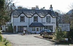
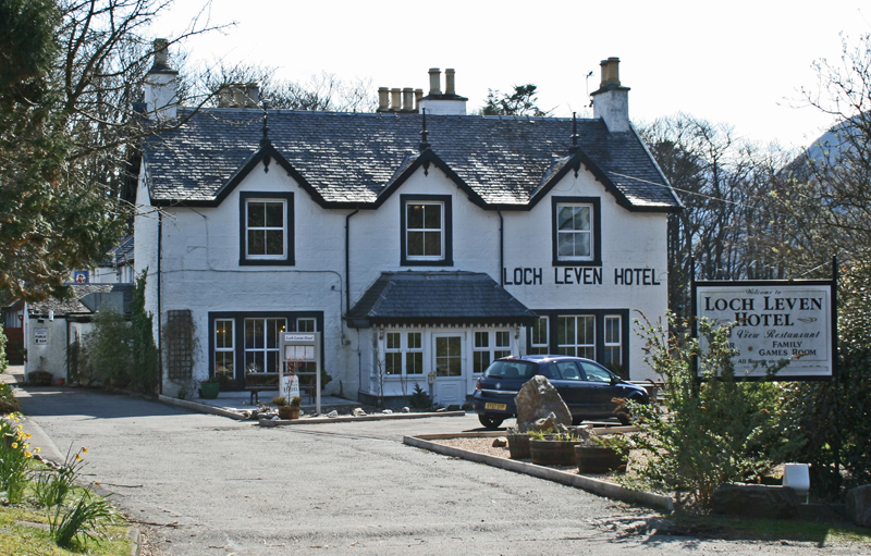
Loch Leven Hotel
As with the Ballachulish Hotel above, there has almost certainly been an Inn or Hotel on the current site since the early 18th Century when the ferry started operating, if not long before. However, the current building appears to largely date from c1860.
Stewarts leave Ballachulish Estate
After perhaps centuries of ownership, the Stewarts left Ballachulish in 1860. It is unclear whether they sold up or relinquished the estate due to debts, or indeed whether some other factor saw the estate change hands.
1863
Ballachulish Pier
The remains of the pier at South Ballachulish appear to date from 1863, and were built by the Ballachulish Estate for the use of the estate. However, there are records of Steamers calling at Ballachulish prior to this, suggesting that there was an earlier pier either on this site or nearby.
The house at the top of the pier has the appearance of being a waiting room or booking office for Steamers, and may be of a similar age. However, this is not confirmed as yet.
1860s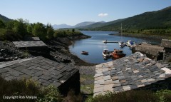
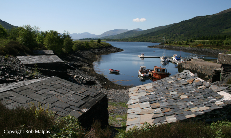
Boat Sheds
The unique slate boatsheds found along the shore of Ballachulish are first marked on the OS maps in the 1890s, but it is believed that they are older, or replace older structures, and were simply omitted from the earlier map, possibly due to the changing shoreline as the slate waste was dumped in the loch.
Read More: Ballachulish Boatsheds
Back to Pre-1800 | Forward to 1870-1899